Lawrence County Maps
Lawrence County First Landowner Maps
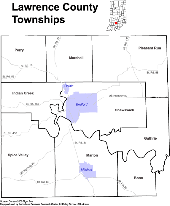
2000 Lawrence County Township Map
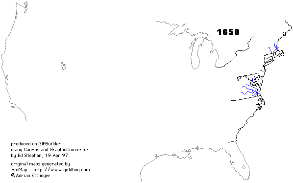
Animated County Map of USA
Genealogy Inc. – Indiana Antique Maps & Atlases
USGS Geographic Names Information System queries
County History Preservation Society
STATS Indiana Township Maps
![]()
BONO TOWNSHIP is located in the southeastern corner of the county, and is bounded on the north by the East Fork of White River, and on the West by Marion Township, on the east by Washington County and on the south by Orange County.
FLINN TOWNSHIP is situated on the eastern border of the county near the center, and was called after the Flinn family, and is bounded on the south by the East Fork of White River, and on the north and west by Shawswick Township and on the east by Jackson County. Not until the year 1817 was there a land entry made in the township. [The township once known as Flinn is now included in portions of Shawswick, Pleasant Run and Guthrie Townships.]
GUTHRIE TOWNSHIP was the last township formed was named for one of the oldest and most prominent families in the county from the very first settlement to the present time. The East Fork of White River from where it enters the county to the north of Guthrie's Creek, forms its southern boundary. On the north, Shawswick and Flinn Townships bound it and Jackson County on the east. It is traversed its entire length in a zigzag course by Guthrie's Creek, into which Back Creek empties from the north.
INDIAN CREEK TOWNSHIP of the three townships lying on the western border, the middle one is Indian Creek. It is so named for the creek that enters it near the northwest corner, and after flowing in a sinuous and semicircular direction, leaves the county near the southwest corner of the township. Salt Creek and the East Fork of White River form the eastern and southern boundaries.
MARION TOWNSHIP is located on the southern border near the middle of the county, and is bounded on the north by the East Fork of White River, on the east by Bono Township, on the west by Spice Valley Township and on the south by Orange County.
MARSHALL TOWNSHIP is the middle of three townships that form the northern tier in the county. It is the smallest one in the county, containing twenty-eight sections in all, and was named for John Marshall, the renowned Chief Justice of the United States.
PERRY TOWNSHIP is located in the northwest corner and was named for the renowned Commodore of the American Navy who won the famous victory over the British on Lake Erie in the war of 1812, and whose dispatch concerning that event contributed not a little to his celebrity.
PLEASANT RUN TOWNSHIP is the northeast corner township and was created at the organization of the county in 1818. The surface of the land in Pleasant Run Township is generally rough and broken, and therefore but poorly adapted to tillage. This portion of the county was the latest settled of any.
SHAWSWICK TOWNSHIP is perhaps the most important township in Lawrence County. Situated in the central part of the county, it is watered on the south by the East Fork of White River, and on the west by the next most important stream in the county, Salt Creek. Flowing entirely across it from northeast to southwest is Leatherwood Creek, along which is the best farming and agricultural land within the bounds of the county.
SPICE VALLEY TOWNSHIP is located in the southwest corner of the county. On the west and south it is bounded by Martin and Orange Counties respectively, while on the north the East Fork of White River forms nearly the whole boundary, and on the east is Marion Township.